PakAlumni Worldwide: The Global Social Network
The Global Social Network
Managing Droughts and Floods in Pakistan
Flood-Drought Cycles:
Before the summer floods of 2010, the Indus had turned into a muddy puddle in parts of Sindh. Britain's Financial Times reported at the the time that "angry farmers marched through villages in Sindh demanding access to water. Those who can no longer turn a profit in the fields are increasingly resorting to banditry or migrating to urban shanties".
Earlier, there was a 2009 report by the Woodrow Wilson International Center saying that the melting Himalayan glaciers have exacerbated Pakistan’s shortages. And the World Bank warned that Pakistan could face a “terrifying” 30-40 per cent drop in river flows in 100 year’s time. Now large parts of Sindh are under water for the second year in a row, destroying lives and standing crops.
Growing Water Scarcity:
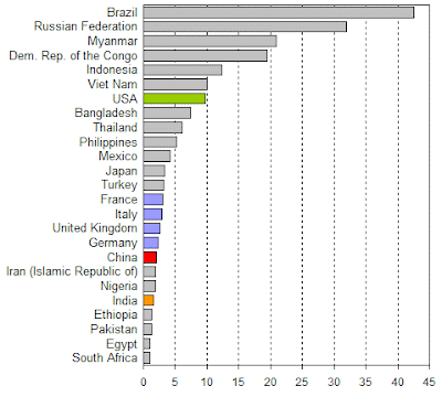
According to the United Nations' World Water Development Report, the total actual renewable water resources in Pakistan decreased from 2,961 cubic meters per capita in 2000 to 1,420 cubic meters in 2005. A more recent study indicates an available supply of water of little more than 1,000 cubic meters per person, which puts Pakistan in the category of a high stress country. Using data from the Pakistan's federal government's Planning and Development Division, the overall water availability has decreased from 1,299 cubic meters per capita in 1996-97 to 1,101 cubic meters in 2004-05. In view of growing population, urbanization and increased industrialization, the situation is likely to get worse. If the current trends continue, it could go as lows as 550-cubic meters by 2025. Nevertheless, excessive mining of groundwater goes on. Despite a lowering water table, the annual growth rate of electric tubewells has been 6.7% and for diesel tubewells about 7.4%. In addition, increasing pollution and saltwater intrusion threaten the country's water resources. About 36% of the groundwater is classified as highly saline.
So what can Pakistan do to manage these disastrous cycles of floods and droughts?
1. Build Dams and Dykes:

As the flood disaster takes its toll yet again, there are reports of USAID and ADB considering funding the $12 billion Bhasha Dam in Pakistan. The project is located on Indus River, about 200 miles upstream of the existing Tarbela Dam, 100 miles downstream from the Northern Area capital Gilgit in Gilgit-Baltistan region. The dam's reservoir would hold so much water that it could have averted last year's devastating floods. It would also provide enough electricity to end Pakistan's crippling shortages, according to a report in the Guardian newspaper. The massive dam on the Indus river would provide 4,500MW of renewable energy, making up for a shortfall causing up to 12 hours of load shedding on daily basis across Pakistan. The reservoir would be 50 miles long, holding 8.5 MAF (million acre feet) of water.
In addition to large dams, there is also a need to build and maintain dykes and start other flood-control projects in flood-prone areas like Badin and Thatta in Sindh.
2. Conserve Water:
Building Bhasha and several other proposed dams will help in dealing with water scarcity, but the growing population will continue put pressure on the vital resource.

Serious conservation steps need to be taken to improve the efficiency of water use in Pakistani agriculture which claims almost all of the available fresh water resources. A California study recently found that water use efficiency ranged from 60%-85% for surface irrigation to 70%-90% for sprinkler irrigation and 88%-90% for drip irrigation. Potential savings would be even higher if the technology switch were combined with more precise irrigation scheduling and a partial shift from lower-value, water-intensive crops to higher-value, more water-efficient crops. Rather than flood irrigation method currently used in Pakistani agriculture, there is a need to explore the use of drip or spray irrigation to make better use of nation's scarce water resources before it is too late. As a first step toward improving efficiency, Pakistan government launched in 2006 a US $1.3 billion drip irrigation program that could help reduce water waste over the next five years. Early results are encouraging. "We installed a model drip irrigation system here that was used to irrigate cotton and the experiment was highly successful. The cotton yield with drip irrigation ranged 1,520 kg to 1,680 kg per acre compared to 960 kg from the traditional flood irrigation method," according to Wajid Ishaq, a junior scientist at the Nuclear Institute for Agriculture and Biology(NIAB).

Beyond the government-funded experiments, there is a drip irrigation company called Micro Drip which is funded by the Acumen Fund. Micro Drip develops and provides products and services as poverty alleviation solutions to small farmers in Pakistan’s arid regions. It provides a complete drip irrigation system along with agricultural training and after-sales support to enable farmers to extract a higher yield from their land at a much lower cost of input.
So what is holding up Pakistan's progress on water management?
1. Lack of Funds:
Pakistani government revenues continue to be limited by slow economic growth and widespread culture of tax evasion. The biggest culprits are the ruling feudal politicians who oppose any attempt to levy taxes on their farm income. The limited resources the state does have are usually squandered on political patronage doled out to ruling politicians' supporters in the form of capricious grants, huge loans (defaulted with impunity), and plum jobs in bloated government and the money-losing state-owned enterprises. The result of this blatant abuse, waste and fraud is that the budget allocations for vital long-term investments in education, health care and infrastructure development projects are regularly slashed thereby shortchanging the future of the nation.
2. Corruption and Security Concerns:
The NY Times recently reported that "Washington’s fears of Pakistani corruption and incompetence has slowed disbursal of the money". The story reinforces the widely-held view that even after the funding is arranged, the corrupt and incompetent politicians and their hand-picked civilian administrators make any development progress slow and difficult. Such problems are further exacerbated by significant security issues in parts of the country severely plagued by ongoing militancy.
Existential Threat:
The Taliban who get all the coverage do not pose an existential threat to Pakistan. Generations of military families have periodically fought FATA insurgencies. For example, Shuja Nawaz, the author of Crossed Swords says that his grandfather, his uncle and his cousin have all been deployed in Waziristan by the British and later Pakistani governments in the last century and a half. American withdrawal from the region will eventually calm the situation in Waziristan, and the rest of the country.
Climate change and the growing water scarcity are the main long-term existential threats to Pakistan and the region. Water per capita is already down below 1000 cubic meters and declining
What Pakistan needs are major 1960s style investments for a second Green Revolution to avoid the specter of mass starvation and political upheaval it will bring.
Related Links:
Haq's Musings
Growing Water Scarcity in Pakistan
Political Patronage in Pakistan
Corrupt and Incompetent Politicians
Pakistan's Energy Crisis
Culture of Tax Evasion and Aid Dependence
Climate Change in South Asia
US Senate Report on Avoiding Water Wars in Central and South Asia
-
Comment by Riaz Haq on April 23, 2016 at 9:40am
-
BBC News - BBC Pop Up: A lack of #water and #wives in #India. #Drought #FemaleGenocide #Women
http://www.bbc.com/news/world-asia-india-36104869
"Who would give their daughter to this village?" That's the question posed by one man in an Indian village devastated by an ongoing drought in the country.
The majority of young men in Gopipur, in the Chitrakoot district about 400 miles south of New Delhi, say that the shortage of water, and its crippling impact on the local economy, has made it harder for them to get married.
It's one of the unexpected social consequences of a drought that the Indian government now says is affecting at least 330 million Indians.
BBC Pop Up went to the community where nearly 5,000 people rely on a small naturally-fed well for drinking and bathing water.
-
Comment by Riaz Haq on August 12, 2016 at 8:24am
-
#Pakistan has more #glaciers than almost anywhere on Earth. But they are at risk. #K2 #Himalaya #water http://wpo.st/sver1
With 7,253 known glaciers, including 543 in the Chitral Valley, there is more glacial ice in Pakistan than anywhere on Earth outside the polar regions, according to various studies. Those glaciers feed rivers that account for about 75 percent of the stored-water supply in the country of at least 180 million.
But as in many other parts of the world, researchers say, Pakistan’s glaciers are receding, especially those at lower elevations, including here in the Hindu Kush mountain range in northern Khyber Pakhtunkhwa province. Among the causes cited by scientists: diminished snowfall, warmer temperatures, heavier summer rainstorms and rampant deforestation.
To many, the 1,000-square-mile Chitral Valley has become a case study of what could await the rest of the world if climate change accelerates, turning life-supporting mountains into new markers of human misery.
“It’s already happening here, and my thinking is, in the coming years it will just go from bad to worse,” said Bashir Ahmed Wani, a Pakistani forestry specialist with the Asian Development Bank.
Over the past six years, the Chitral Valley has also experienced three major floods that many Pakistani scientists attribute to climate change. The floodwaters killed more than 50 people and stranded hundreds of thousands while undercutting a once-vibrant tourist industry still struggling to rebound after Sept. 11, 2001.
Despite such calamities, the valley has come to symbolize the way a poorly educated populace can compound the effects of climate change, creating a cycle of hardship that is difficult to break as the needs of humans compete with the needs of nature. Its glaciers offer a stark example.
As the valley’s population has soared — from 106,000 in 1950 to 600,000 today — most residents get just two to four hours of electricity a day, they say. Without reliable refrigeration, they turn to vendors hawking chunks of the valley’s shrinking snowpack.
Every day, residents say, scores of these entrepreneurs drive five to seven hours to the mountain peaks, where they hack into the glaciers — or scoop up the pre-glacial snow — and load the haul into their jeeps and trucks. Back in the valley, they shovel the snow and ice into shopping bags and sell it for 50 cents a bag.
“There are no fans, no refrigerators working, so I will store this for cooler water and then use it for drinking,” said Ubaid Ureh, 46, as he held two dripping bags. “The doctors say we shouldn’t drink it, but we have no choice.”
Hameed Ahmed Mir, a local biodiversity expert who has worked for the United Nations, said the harvesting of the Chitral Valley’s glaciers saps in one day what otherwise could be several months’ worth of stable water supply.
One cubic yard of ice weighs about a ton — enough to supply four to seven families with drinking water for several days — and one vehicle can carry three to four tons of snow or ice, he said: “Then multiply that by 200 vehicles per day.”
Khalil Ahmed, a former project manager for the U.N.-supported Glacial Lake Outburst Floods Project, said Pakistani law does not make it clear whether the government or the public owns the country’s vast glacial reservoirs.
“We are trying to initiate a dialogue with the local people, but these are poor people,” he said, noting that glaciers in the neighboring territory of Gilgit-Baltistan are also being sold off.
---------------
Other scientists play down the threat, saying there are so many glaciers in Pakistan that it’s like taking water from an ocean. But even they admit that the sight of desperate families waiting to buy snow underscores the challenges facing this valley.
--------------------
Some researchers think that the glaciers in the Karakorum and Himalayan mountains in Gilgit-Baltistan may even expand as weather patterns shift and more precipitation falls over the highest peaks as snow. Many of Pakistan’s glaciers are also covered in silt and debris, which helps insulate them.
-
Comment by Riaz Haq on August 27, 2016 at 4:46pm
-
Thar Revisited:
Last week I had the chance to visit Thar again after more than a decade. While it remains an extremely poor and least developed region of the province of Sindh, I was struck by a few changes that have the potential of transforming the region into a vibrant economic player. Water is the most basic need in a desert. Last time round, I observed that Thardeep, a rural support organisation that has worked in the area since the early nineties, had achieved some success in improving provision and quality of drinking water in selected areas. Traditional birth attendants, some dispensaries and a few “barefoot” doctors was all that it could manage in the field of health. It also ran a number of schools. Linkages between craftswomen and middlemen from the market were few and far between. Government presence was minimal. The district hospital in Mithi was a mess. Roads were almost nonexistent.
Fast forward to August 2016. The road from Karachi to Thatta is a shame and Thatta to Thar via Badin is tolerable. Enter Thar and it is a different world. The main road here is probably the best highway of Sindh. It leads to coal mining areas, power stations and the gasification plant. Coal mining is a joint venture of the Government of Sindh and ENGRO, subcontracted further to a concern named Bilal. There is no knowing whether usable coal will eventually be available to the power plant being constructed next door. The coal gasification plant is no more than a monument to our atomic veteran.
The impact of the road, augmented by mobile connectivity, is multidimensional. Walking long distances has given way to motorbikes and overloaded buses have taken the place of kekras, the rickety shuttle truck-bus of the World War II vintage. Children suffering from malnutrition and other ailments are reported directly to the media as well as the hospital in Mithi on mobile phones. The high numbers of the suffering children had always existed; only the media was late in discovering these cases. The media attention did bring politicians and bureaucrats to the region, facilitated of course by the road. The hospital in Mithi is now much better staffed and well-stocked with medicines. It is now a thriving town with a good number of schools and a college. Even an English-medium private school was in evidence. A sub-campus of a university is also coming up. Locals complained about the lack of girls schools, especially at the post-primary level. This is a sign of growing awareness. There was also frustration that the locals are not given the party tickets for the National and Provincial assembly seats. Mobile connectivity and the road have linked the famous craftswomen of Thar with the main markets much more effectively. At a community meeting in Islam Kot, women were quoting prices that broadly corresponded with the prices charged in Karachi’s Zeb un Nisa Street.
Another change is the large number of government buildings, most of them left incomplete. Many that are completed, are uninhabited. Those complete and inhabited are poorly maintained. The tourist complex built at the legendary Marvi well is a case in point. A beautiful tourist complex in Nagar Parkar, designed by friend Arif Hasan, funded by Sindh’s Planning and Development Department and managed by Thardeep is another case in point.
At the end of the day, there may or may not be good quality coal or power, but the very presence of the road is rapidly opening up the area. As for power, the people are beginning to learn that the best off-grid solution is the sun that shines over Thar most of the time. I, though, had the good fortune of witnessing rains and greenery in a desert — an exhilarating experience.
http://tribune.com.pk/story/1169946/thar-revisited/
-
Comment by Riaz Haq on July 10, 2017 at 8:00pm
-
#Mobile #CellPhone & #Satellites Improve #Farming in #Pakistan. #Irrigation #Agriculture #Water #Technology
https://learningenglish.voanews.com/a/mobile-phones-improve-farming...
Mobile phones and satellites are becoming valuable farming tools in Pakistan.
A new program there uses satellite information to estimate how much water a field needs. The satellite then sends this information by text message to farmers' mobile phones.
The program’s aim is to prevent the farmers from overwatering crops. A 2013 report from the Asian Development Bank says Pakistan has some of the most severe water problems in the world. The country’s water availability is similar to Syria’s, where a lack of rainfall has intensified civil war.
Pakistan is only able to store water that can last up to 30 days. That is far below the recommended storage amount of 1,000 days.
Several issues have led to Pakistan’s water crisis. They include climate changes, a growing population, local water mismanagement and a greater demand on farmers.
Many fear the water crisis could weaken relations between Pakistan and India. The two countries share the Indus River.
Turning off the water
Many older Pakistani farmers received agricultural training several years ago, when water was more readily available. They know the risks that come with underwatering crops.
But using too much water can reduce crop harvests.
The Pakistan Council of Research in Water Resources found that rice farmers were using more than three times as much water as they needed.
The council asked the Sustainability, Satellites, Water, and Environment research group, at the University of Washington, to get involved. The council wanted the research group to use science to help inform irrigation choices.
Pakistan's program started with 700 farmers in the spring of 2016. By January, 10,000 farmers were receiving text messages with a water amount advisory. For example, one message read: "Dear farmer friend, we would like to inform you that the irrigation need for your banana crop was 2 inches during the past week."
The messages come from a fully-automated system. It uses publicly available satellite information. It also uses models to compute how much water each farmer needs to irrigate.
A national effort
The council plans to expand the program for use across the country, and expects millions of farmers to participate. But first the system must be reviewed.
The researchers want to know how easy it is for farmers to use, and how many follow the irrigation advisories. They also want to know how accurate it is and whether it saves farmers money.
They are collecting responses from farmers over the phone.
Faisal Hossain is with the University of Washington. He says he has not seen a report on the results yet. However, the group heard from one farmer in the program who said he was able to get about 700 kilograms more wheat than his neighbor. The farmer said he believes the irrigation advisories made this possible.
Expanding the program may be difficult. The council may need to work harder to persuade farmers to trust the technology. Those working on smaller farms may not feel comfortable depending on mobile phone technology.
Mobile phones are already very common in Pakistan, however. And last year the Punjab government announced that it would give out 5 million smartphones to farmers.
-
Comment by Riaz Haq on September 9, 2017 at 4:53pm
-
STRATEGIC SUSTAINABLE DEVELOPMENT OF GROUNDWATER
IN THAR DESERT OF PAKISTAN
An integrated research study, based on geoelectric
scanning, drilling and seismic-data
analyses, has been carried out to delineate
subsurface hydro-geological conditions beneath
the Thar Desert. Regional gradient maps of
surface elevation, top of subsurface Oxidized
Zone, top of coal-bearing formation(s) and the
deeply buried basement have been prepared,
covering almost the whole of Thar Desert. These
gradient maps, analyzed in conjunction with the
annual rainfall data, reveal the existence of
encouraging subsurface hydrogeological
conditions, associated with the sedimentary
sequences and the basement. From the results of
the study, it is observed that perch water aquifers,
commonly being utilized throughout the Thar, are
present at the bottom of the dunesand-zone, with
fluctuating yield controlled by the annual rainfall
cycles. At places, vertical electric-soundings
indicate good prospects for the better water,
associated with the basement complex. The
strategic development of groundwater, based on
scientific exploration and exploitation, from the
deep sedimentary and basement aquifers, can dedesertify
the Thar, accelerating the socioeconomic
stability of the people of the region.
http://www.sciencevision.org.pk/BackIssues/Vol7/Vol7No3-4/Vol7No3%2...
-
Comment by Riaz Haq on September 9, 2017 at 4:59pm
-
Thar Aquifer. Source: Research Gate
-
Comment by Riaz Haq on September 9, 2017 at 5:29pm
-
Blessings and bane that come with rain
Zulfiqar Kunbhar September 3, 2017
http://tns.thenews.com.pk/blessings-bane-come-rain/#.WbSExtOGN-U
Sindh’s Thar Desert has witnessed severe drought in the past four years. The long dry spell caused acute shortage — of food for humans, fodder for livestock and water for wildlife. During this worst drought in the recent history, hundreds of infants have died of malnutrition. The famine like situation has killed not just livestock, an important source of livelihood, but also wild species.
But the recent monsoon rains had a magical effect on the desert which has turned green from brown, promising good times ahead not just for humans but wildlife as well.
At the same time poaching and trafficking of baby wild animals including peafowl, deer, partridge and wild rabbit in the region is picking up. Thar Desert is home to around 300 species of mammals, birds and reptiles.
Prolonged drought had impacted the economy, society and environment of Thar Desert. Natural water ponds (locally known as Tarae) dried up and ground water level deepened, affecting all forms of life. There was no cultivation. Green pastures, which are the main source of food for livestock and wildlife, had depleted. Locals would spend most of their time in search of food and water. In the drought years, almost half of the total population of locals migrated along with their cattle to the neighbouring barrage areas in search of food. So did the wildlife species.
Although last year there were some rains in the desert they were not on time, hence not beneficial for locals as they could not cultivate crop due to delayed rains. Also, there was no greenery.
This year monsoon arrived on time. The desert received the first rain in the beginning of July that continued for several days, restoring the beauty of the desert.
Rain has provided the much-awaited relief to the living beings and natural habitat. Thar Desert is recovering from the bad impacts of drought. Wetter Thar means greenery and pastures all around as this part is considered the most fertile desert. There is greenery on vast areas of sand dunes locally called ‘Bhit’. That also means better food supply to flora and fauna of the area.
Much of Thar Desert’s portion lies in Tharparkar district of Sindh, stretching over 22,000 square kilometres. 300 kilometres east of Karachi, along Indian border, it has faced persistent but periodic droughts for the past several decades.
-
Comment by Riaz Haq on September 13, 2017 at 10:00pm
-
PM to inaugurate Kachhi canal project today
https://www.pakistantoday.com.pk/2017/09/14/pm-to-inaugurate-kachhi...
DERA BUGTI: Prime Minister Shahid Khaqan Abbasi will be paying a one day visit to Dera Bugti’s Sui area to inaugurate the Kachhi canal project on Thursday. He will also be addressing the gathering at the inauguration ceremony.
The pm will be accompanied by Chief Minister Balochistan Nawab Sanaullah Zehri, Home Minister Balochistan Mir Sarfaraz Bugti and other leaders who are also expected to address the gathering.
In consideration of the occasion, a local holiday has been declared in the district of Dera Bugti today.
Kachhi canal project is of strategic importance for the development of irrigated agriculture in Balochistan. The total estimated cost of the project is around Rs80 billion. The 363km long main canal (of which 351km is lined canal) stretches from Taunsa Barrage in Muzaffargarh to Dera Bugti district.
-
Comment by Riaz Haq on September 19, 2017 at 10:17am
-
Aquifer Recharge Dams
http://www.edwardsaquifer.net/recharge.html
Water enters the Aquifer easily in the Recharge Zone, but the subsurface drainage is generally inadequate to hold all the water that falls in large rain events. Recharge conduits and sinkholes quickly become filled and the remaining water has to flow over the surface and on past the Recharge Zone. So the idea behind recharge dams is that by stopping water and retaining it behind structures, more can be forced to go into the Aquifer. Some of it could be made available for production from wells while the remainder would help sustain flows at Comal and San Marcos Springs above levels that are critical for maintaining endangered species habitats.
In the 1960s and 70s, there was a rash of dam building for flood control purposes, and many of them had the side effect of also increasing recharge (see article below).
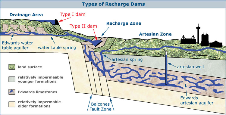
Between 1990 and 1998, six studies were completed that analyzed the potential for enhanced recharge using dams (HDR, 1991-1998). There are two types of recharge dams that have been proposed and considered, known as Type I and Type II dams.
Type I dams would be constructed on the creeks and rivers of the Edwards Plateau, the catchment area for the Aquifer, where they would catch storm runoff and release it slowly toward the Recharge Zone. Several studies have determined that Type I dams would have to be very large and expensive and would inundate large areas during rainy times and leave large mud-crusted areas during dry times, so authorities consider them generally not feasible. For example, there is a site with good potential to recharge large amounts of water, but it would have the unfortunate side effect of periodically inundating Garner State Park.
Type II dams would be constructed on the Recharge Zone itself and would stop water as it runs off the plateau, allowing more time for it to go into the ground. Some of the best sites for Type II dams already have dams on them, such as the Medina Lakeand Diversion Lake system, which are estimated to contribute about 37,000 acre-feet per year to recharge (Slattery and Miller, 2004).
There are many issues that complicate the notion of building additional recharge dams. Landowners may not be willing to give up their property for such projects, and the Recharge Zone is one of the most environmentally sensitive areas in Texas. There is a long list of endangered and threatened species that would be impacted by periodic inundation, and numerous archaeological sites would be impacted as well.
Also, excess water that flows over the Recharge Zone without going in is not really “wasted” – there are at least three ways it benefits people and ecosystems downstream. First, there are people who hold surface water rights, so recharge projects would have to ensure that provisions are made for protection or mitigation of impacts on people who rely on surface water. Secondly, waters that bypass the Edwards Recharge Zone can recharge the Carrizo-Wilcox Aquifer, which is a water source for many users on the coastal plain. Finally, waters from the Edwards Plateau support instream flows and the bay and estuary system on the Texas coast. There is increasing concern about maintaining flows for instream and coastal environmental needs and coastal commercial fisheries. In August 2012, the TCEQ adopted rules that outline instream flow standards for major streams in the San Antonio and Guadalupe basins and freshwater inflow needs to the bays and estuaries, and these would have to be considered in any plans to impound and recharge water.
Further, it is not exactly clear who would pay and who would benefit from recharge dams. For example, if people in Bexar county paid to build a dam, most of the water that goes into the Aquifer as a result would emerge as increased flows at Comal Springs, which mainly benefits people other than those who paid. Now it’s true that maintaining springflows in Comal county also benefits Bexar county, because we are all one regional economy and the periods of time that pumping restrictions would have to be imposed would be shorter, but even so, the people in Bexar county who paid for the structure would likely prefer to see some cost sharing by those in Comal county who benefit as well.
Other considerations would be securing the necessary state and federal permits, conducting the myriad of studies required for such permits, acquiring land and/or easements either through negotiations or condemnation, and relocating roads, railroads, and other utilities.
To make recharge dams a success and part of an overall solution, many complicated issues like these would have to be addressed and worked out.
Though many questions and issues exist, the scientists and stakeholders who produced the latest version of the section of the 2012 Texas Water Plan that applies to south central Texas believe there is indeed some potential to build additional Type II recharge dams. They would not be a magic-bullet type of solution and could only supply a small percentage of overall projected water needs. The latest version of the regional water plan produced by the South Central Texas Regional Water Planning Group in 2011, which was incorporated in the 2012 Texas Water Plan, recommended completion of six projects by 2020 and possibly nine more by 2060. The six projects in the first phase would add an estimated recharge of 54,471 acre-feet per year in average conditions and 10,034 acre-feet per year in drought conditions. Each year they would provide 13,451 acre-feet for pumping and 24,401 acre-feet for springflows. The cost would be $159,950,000 (in 2008 dollars).
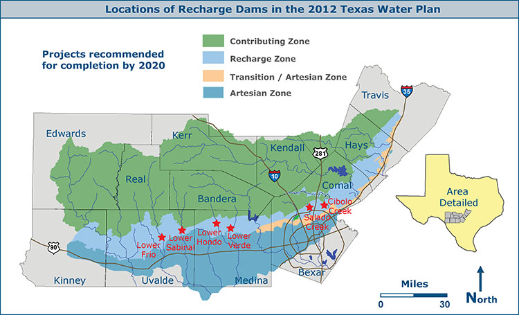
To make recharge enhancement initiatives an equitable and effective Aquifer management tool, the structures would probably have to be developed as regional projects, with the cooperation and involvement of many agencies such as the Edward Aquifer Authority, San Antonio, and numerous other area cities, counties, and purveyors. In it’s latest 2012 Water Management Plan, the San Antonio Water System said the present regulatory environment is not favorable for recharge enhancement initiatives for municipal supply purposes. SAWS said it views the enhancement of recharge as a public good and continues to support implementation as a regional benefit, but it would not be pursuing the matter from the municipal water supply perspective.
Northwest Bexar county dam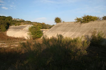
This dam built on the Contributing Zone for flood control also aids recharge by slowing stormwaters down.
Pit cave in NW Bexar county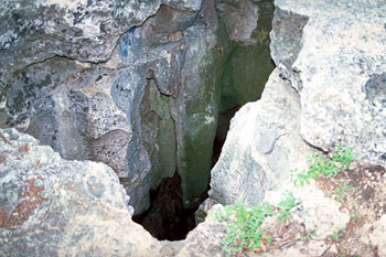
This pit cave in northwest Bexar county is about 60 feet deep. It is in a creekbed near UTSA and accepts recharge water for the Edwards when water is available. There are thousands of such recharge features in the area, many of which have not been documented. Many of these features that are sinkholes today were springs 13,000 years ago when the climate was wetter and cooler. Now that the climate is much drier, the direction of flow is reversed and water only goes in. Note the weathered remnants of a large stalactite that formed when this spot was still overlain by thousands of feet of limestone.
San Antonio Express-News, February 26, 1979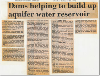
A vintage article that discusses how the construction of many flood control dams in Bexar county also served to provide additional recharge.
-
Comment by Riaz Haq on December 5, 2017 at 5:37pm
-
Rainwater harvesting in Thar
Mohammad Hussain KhanDecember 04, 2017
https://www.dawn.com/news/1374301
The Sindh Small Dams Organisation of the provincial irrigation department has been building recharge and storage dams across the province. So far, 44 small dams have been completed and 30 are under construction to irrigate around 155,000 acres of land. In all, 70 recharge and four storage dams are to be built by the organisation.
“If a dam in our village [Chanida] is filled like the Ranpur [dam], we can cultivate the onion crop on 200 acres,” Eidal Kumar tells this writer at the dam’s site in Nagarparkar. “Whatever water is currently available [in the Chanida dam] is used by livestock,” he adds.
Recently, the multibillion-rupee Sindh Resilience Project was launched under which three small dams in Nagarparkar and 12 in Kohistan belt are to be built.
The World Bank-funded project aims to mitigate flood and drought risks in selected areas and strengthen Sindh’s capacity to manage natural disasters. The Sindh government would share 20pc cost of the project.
Of the Rs10bn cost, 80pc would be spent on small dams and 10 main river Indus’ dykes which needed refurbishment after recent floods.
The accumulation of rainwater replenishes/recharges groundwater aquifers and then water is lifted through pumps by growers for rearing animals and cultivating crops.
The sandy soil of Thar absorbs water quickly, but water table in groundwater aquifers around such dams gets improved considerably.
“At some sites [of dams], groundwater level is recorded at 20 feet which was 100 feet before it rained in that area,” says Zahid Sheikh, an irrigation officer who was looking after small dams’ construction until recently.
Besides recharge or storage dams, spate irrigation is another technique applied in areas located on the right bank of the Indus river such as Jamshoro, Dadu, Qambar-Shahdadkot and districts like Thatta, Khairpur and Malir.
According to an old study conducted by the National Engineering Services of Pakistan, around 1.4 million acres could be brought under spate irrigation for cropping in Sindh, which has such 33 sites for water conservation of hill torrents. Small farmers of these areas have remained dependent on hill torrents during Kharif crops.
Ashfaq Soomro of Research and Development Foundation said according to their study, improved structures of ponds can serve to reduce seepage and evaporation losses.
Unfortunately, Sindh has not carried out a geographical study to develop comprehensive data set for a planned effective intervention. “Generally, communities in such difficult areas are left to deal with problems on their own,” commented an expert.
Ahmad Zeeshan Bhatti of the Islamabad-based Pakistan Council of Research in Water Resources says a detailed mapping of Tharparkar is needed for determining potential sites to build rainwater harvesting. Since Thar’s soil is sandy, it increases the seepage ratio. Road catchment could be built to accelerate the pace of rainwater’s runoff after a cost analysis.
India has installed solar panels in water bodies to block sunlight that otherwise accelerates the pace of evaporation. The wind velocity could be controlled by raising hedges around dams, he said.
A proposal for mapping entire arid region was submitted to the federal government after hundreds of newborns died in Tharparkar in 2014 owing to malnourishment. The file has been gathering dust since then.
Twitter Feed
Live Traffic Feed
Sponsored Links
South Asia Investor Review
Investor Information Blog
Haq's Musings
Riaz Haq's Current Affairs Blog
Please Bookmark This Page!
Blog Posts
Pakistan Pharma Begins Domestic Production of GLP-1 Weight Loss Drugs
Several Pakistani pharmaceutical companies have started domestic production of generic versions of GLP-1 (Glucagon-Like Peptide-1) drugs Ozempic/Wegovy (Semaglutide) and Mounjaro/Zeptide (Tirzepatide). Priced significantly lower than the branded imports, these domestically manufactured generic drugs will increase Pakistanis' access and affordability to address the obesity crisis in the country, resulting in lower disease burdens and improved life quality and longer life expectancy. Obesity…
ContinuePosted by Riaz Haq on December 19, 2025 at 10:00am
WIR 2026: Income and Wealth Inequality in India, Pakistan and the World
The top 1% of Indians own 40.1% of the nation's wealth, higher than the 37% global average. This makes India one of the world's most unequal countries, according to the World Inequality Report. By contrast, the top 1% own 24% of the country's wealth in Pakistan, and 23.9% in Bangladesh. Tiny groups of wealthy elites (top 1%) are using their money to buy mass media to manipulate public opinion for their own benefit. They are paying politicians for highly favorable laws and policies to further…
ContinuePosted by Riaz Haq on December 15, 2025 at 1:00pm — 8 Comments
© 2025 Created by Riaz Haq.
Powered by
![]()
You need to be a member of PakAlumni Worldwide: The Global Social Network to add comments!
Join PakAlumni Worldwide: The Global Social Network