PakAlumni Worldwide: The Global Social Network
Shaheen 3 Can Reach Deep Inside India & Israel and Boost Pakistan's Space Program
Pakistan has successfully tested Shaheen III ballistic missile with 1700 mile range. The intermediate range missile can hit deep inside India and Israel. Its multi-stage solid-fuel technology can also be used to launch satellites into space. It has been jointly developed by the National Engineering and Scientific Commission (NESCOM) and the Space and Upper Atmosphere Research Commission (SUPARCO). It's the latest example of dual-use technology.
|
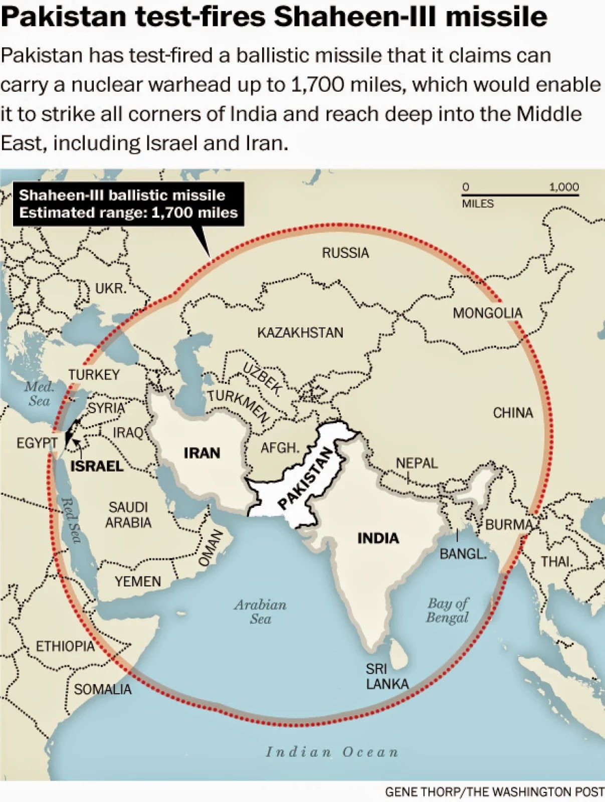
The missile was successfully test-fired into the Arabian Sea on Monday, March 9, 2015, according to the Strategic Plans Division (SPD) which oversees Pakistan’s nuclear program. Announcing the result, General Zubair Mahmood Hayat, the head of SPD, congratulated NESCOM (National Engineering and Scientific Commission) scientists and engineers for “achieving yet another milestone of historic significance.”
Shaheen-III is the latest in the series of the indigenously produced Shaheen-I and Shaheen-II, which had shorter ranges. “The test launch was aimed at validating various design and technical parameters of the weapon system at maximum range,” the Pakistani military said in a statement. Pakistani military leaders are trying to maintain a “credible deterrence” as arch-rival India continues to invest heavily in military hardware.
Since the technology used in satellite launch vehicles (SLV) is virtually identical to that used in a ballistic missile, Shaheen 3, the latest enhancement to Shaheen series of missiles, is expected to boost Pakistan's space program as well. Several nations, including India and Israel recently, have used same rocket motors for both ballistic missiles and satellite launch vehicles (SLVs). Israel's Shavit SLV and India's SLV-3 are examples of it.
The success of Shaheen 3 multi-stage solid-fueled ballistic missile is a confirmation of Pakistan's determination to ensure its security AND to pursue its space ambitions at the same time. I congratulate Pakistani engineers and scientists at NESCOM and SUPARCO on their hard work, continuing deep commitment and the latest achievement.
Related Links:
Revolution in Military Affairs
Pakistan Defense Production Goes High-Tech
Drones Outrage and Inspire Pakistanis
Pakistan's Biggest Ever Arms Bazar
Genomics and Biotech Advances in Pakistan
Riaz Haq
Pakistan hyper-spectral satellite Imran Shah kazmi on TikTok
https://www.tiktok.com/t/ZTM2xm98x/
AI Overview
Hyperspectral imaging is a technique that captures an image and, for each pixel, provides a detailed spectrum of light, revealing the material's chemical composition and physical properties. Unlike multispectral imaging, which uses only a few broad wavelength bands, hyperspectral imaging uses many narrow, contiguous bands to create a "data cube" that functions like a continuous spectrum for each pixel, enabling the precise identification of objects, materials, and their conditions. This technology has diverse applications in fields like agriculture, food processing, environmental monitoring, medicine, and waste sorting.
AI Overview
Pakistan set to launch hyperspectral satellite in October
Pakistan's Space and Upper Atmosphere Research Commission (SUPARCO) is set to launch its first modern hyperspectral satellite in October 2025. This satellite will capture detailed information on Earth's surface composition and will be used for agriculture, mineral exploration, and disaster management by providing precise data on soil, plants, water quality, and more. The launch marks a significant advancement in Pakistan's space technology capabilities, allowing for enhanced natural resource management, national security, and response to climate events.
Key Features and Applications
Agriculture: Provides farmers with real-time data on soil health, crop status, and water quality, promoting sustainable practices.
Mineral Exploration: Helps map resources like copper and rare earths.
Disaster Management: Enables accurate tracking of events such as floods, earthquakes, and glacier melting.
Environmental Research: Aids in monitoring pollution and climate change factors.
National Security: Offers enhanced surveillance and geospatial intelligence.
Significance
Technological Leap: Positions Pakistan among nations with advanced space-based data capabilities.
Self-Reliance: A step towards a data-driven and self-reliant Pakistan.
Economic and Security Benefits: Links technology, economy, and security through data-driven insights.
Sep 29
Riaz Haq
Mario Nawfal
@MarioNawfal
🚨🇵🇰 PAKISTAN JUST LAUNCHED ITS FIRST-EVER EARTH OBSERVATION SATELLITE
Pakistan just entered a new space era with the successful launch of PRSC HS-1, its first hyperspectral Earth observation satellite.
The satellite lifted off from China’s Jiuquan Satellite Launch Centre on a Kinetica-1 rocket.
PRSC HS-1 can analyse Earth’s surface in hundreds of spectral bands, tracking crops, water, minerals, pollution, and more with scientific precision.
This marks a major leap for SUPARCO and Pakistan’s growing space program.
Think of it as Earth’s MRI scanner, and Pakistan now has the tech.
Source:
@OSPSF
https://x.com/MarioNawfal/status/1980046305335390214
--------------
AI Overview
A hyperspectral satellite is an Earth observation satellite that uses advanced imaging technology to capture hundreds of narrow, contiguous spectral bands of light, creating a detailed "spectral fingerprint" for every point on the ground. This allows it to analyze the physical and chemical composition of materials and detect subtle differences invisible to the naked eye or traditional cameras. Applications include agriculture, environmental monitoring, geology, and disaster management.
How it works
Hundreds of bands: Unlike RGB cameras that see red, green, and blue, or even multispectral sensors that use up to 36 broad bands, a hyperspectral sensor captures data across hundreds of very narrow bands of the electromagnetic spectrum.
Spectral fingerprint: By stacking these hundreds of narrow images, the satellite creates a 3D "spectral cube" for each pixel, where the third dimension is the spectral information. This provides a unique spectral signature for every material, from types of plants to minerals to water.
Detailed analysis: This high spectral resolution allows for the identification and analysis of specific materials based on their unique light-reflecting properties. For example, a hyperspectral satellite can distinguish between different tree species or detect the early signs of drought stress in a crop.
Key applications
Agriculture: Monitoring crop health, assessing soil conditions, and detecting drought stress or disease before they are visible.
Geology: Mapping mineral deposits, providing precise geochemical data, and reducing exploration costs.
Environmental monitoring: Tracking water quality, detecting pollutants, and monitoring changes in land use.
Disaster management: Assessing damage from natural disasters and monitoring geohazard risks.
Other areas: Forestry, climate change research, defense, and security.
yesterday
Riaz Haq
Hyperspectral imaging Applications in Defense and Security
https://headwallphotonics.com/hyperspectral-imaging-applications-in...
Our hyperspectral imaging sensors are used across a variety of defense and government applications. These include small satellites, high-altitude reconnaissance aircraft, and medium-altitude commercial aircraft. They are also used aboard many medium- and low-altitude UAVs.
In addition, these small, lightweight, customized Commercial Off-The-Shelf (COTS) sensors can be used on the ground and in vehicles for checkpoint inspections, spectral tagging, border control, and more.
Finally, aircraft and naval vessel corrosion detection is an emerging hyperspectral imaging military application thanks to its ability to deliver high-resolution spectral and spatial data that targets the evidence of metal corrosion.
Reconnaissance and surveillance missions need to rapidly process, exploit, and distribute hyperspectral data from satellites, aircraft and drones. Headwall meets this need with small, lightweight COTS sensors delivering extremely high spectral and spatial resolution across a wide field of view.
In the field, detecting chemical and biological threats calls upon a multi-sensor approach covering spectral ranges from UV-VIS to SWIR. Headwall meets this need with spectral, fluorescence and Raman technologies.
Metal corrosion on aircraft and naval vessels is costly and difficult to detect. Hyperspectral imaging is a proven technology that can identify early signs of corrosion and metal fatigue, providing reduced cost and greater operational uptime for expensive airborne and maritime assets.
yesterday